
The following is an excerpt from a post on one of my other blogs, but it is appropriate for this blog.
There are lots of ideas about the setting of the Book of Mormon, and they are all based on interpretations of the text combined with extrinsic evidence (archaeology, anthropology, geology, geography, etc.). Everyone who creates or endorses one of these scenarios (multiple working hypotheses) naturally thinks that scenario best fits the text and the extrinsic evidence.
Otherwise they would change their minds.
Which is what I did, having accepted M2C (the Mesoamerican/two-Cumorahs theory) for decades until I learned more about Church history and the relevant extrinsic evidence that, in my view, corroborates the teachings of the prophets.
The multiple working hypotheses can be categorized into two groups: those that accept the teachings of the prophets about the New York Cumorah, and those that reject those teachings in favor of another location of Cumorah.
The various hypotheses also rely on different assumptions about how Lehi, Mulek and Jared crossed the oceans (or "the great deep"), given the various ocean currents.
At the end of this post I show the map of the scenario that makes the most sense to me. Reasonable people can differ, of course.
_____
A basic premise of M2C is that Lehi landed on the west coast of Mesoamerica in the midst of an extensive Mayan civilization. Some M2Cers also believe the Mulekites landed in Mesoamericn in the midst of an Olmec (Jaredite) civilization.
These theoretical voyages were shown on the map that RLDS scholar L.E. Hills proposed over 100 years ago.
 |
| 1917 map published by RLDS scholar L.E. Hills |
To make his theory work, Hills put Cumorah in southern Mexico. He specifically rejected what Oliver Cowdery, Joseph Smith, David Whitmer, Brigham Young and everyone else said about Cumorah in New York.
 |
| "Cumorah" in Mexico, according to L.E. Hills |
 |
| BYU Studies map of Cumorah, based on L.E. Hills, as adapted by Sorenson/Welch. |
Next, Tyler Griffin, who is a great guy, an effective teacher, a faithful Latter-day Saint, etc., created a fictional map to represent the Hills/Sorenson/Welch theory for new generations. (Somehow he and his followers think it's a good idea to teach the Book of Mormon using a fictional map more akin to Lord of the Rings than to any real-world setting.)

Obviously, placing the Nephites and Mulekites in the midst of these Mesoamerican civilizations contradicts Lehi's declarations in verse 8-9. Mesoamerica was the opposite of what Lehi described. Again,
8 And behold, it is wisdom that this land should be kept as yet from the knowledge of other nations; for behold, many nations would overrun the land, that there would be no place for an inheritance.
9 Wherefore, I, Lehi, have obtained a promise, that inasmuch as those whom the Lord God shall bring out of the land of Jerusalem shall keep his commandments, they shall prosper upon the face of this land; and they shall be kept from all other nations, that they may possess this land unto themselves.
(2 Nephi 1:8–9)
 |
| Book of Mormon voyages and ocean currents (click to enlarge) |
Then, after King Mosiah led the Nephites to Bountiful, the division of the Lamanites and Nephites looked something such as this, which explains why Cumorah is in New York.
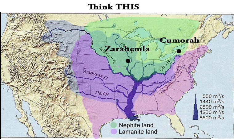
This map also shows Zarahemla across from Nauvoo, pursuant to D&C 125.
No comments:
Post a Comment